Remote Sensing -- What Is It and What Is It Good For?
- kylalangotsky

- Jan 25, 2021
- 4 min read
Hello everyone! Kyla here. Today I'm gonna talk to you about one of my favorite subjects: Remote Sensing!
What is Remote Sensing?
The answer is simpler than it may seem: Observing objects on the surface of the Earth without actually coming into contact with them. Basically: capturing of our planet from far away (hence, "remote").

While we may now think of fancy drones and satellites, this is relatively new technology — original remote sensing imagery came from cameras photographing landscapes from hot air balloons!
Now, of course, our technology is more sophisticated, and we can use any manner of machinery to get our cameras up in the air. Furthermore, most remote sensing now measures electromagnetic waves instead of simply taking your average picture. The sensors can do this in either a passive or active manner, either collective the electromagnetic energy coming off the earth (passive) or sending out a pulse of energy and measuring its reflection from the earth (active).
Electromagnetic What???
Every object releases energy at a specific wavelength on the electromagnetic spectrum. Electromagnetic forces are one of the four fundamental force that occurs between electrically charged particles -- essentially, everything has this force to a degree, but in different ways. These differences are what define the length of an object's wavelengths and thus its spot on the electromagnetic spectrum, pictured below.

There’s the visible spectrum, which we can see with the naked eye, and so much more than that! From gamma rays, to long radio waves, there's so much variance.
Measuring electromagnetic waves instead of simply taking a normal picture allows visualize objects beyond what our eyes can see! Furthermore, recording by electromagnetic waves allows us to easily differentiate between objects, and thus analyze our imagery better.

For example, lush vegetation absorbs all wavelengths on the visible spectrum —except for green, which it reflects.
This is why, when we look at a leaf, we see it as green — the green wavelengths are reflecting off of the leaf and into our eye.
This is also why, when we want to look at how much vegetation an area has, or analyze its health, we mostly examine the green band of satellite imagery, looking only at what is reflected back at the satellite in that range of wavelengths.
Furthermore, all electromagnetic energy is associated with a thermal emission. We can measure different levels of thermal emission to produce infrared maps, such as the ones below that compare day and night:

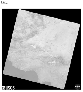

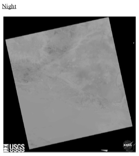
Imagery by USGS
What is Remote Sensing used for?
Remote sensing imagery is used for all manner of projects. It’s mostly digital data measured at different locations and then plotted on a grid. What makes this imagery even more useful than pretty pictures is that we can map them onto real-world XY coordinates in order to observe our landscapes. Remote sensing allows us to observe over both space and time; comparing imagery by location as well as over days, months, years, and decades! It lets us map forest fires, track the weather, visualize and analyze the effects of climate change, and assist in urban planning. It’s also what allow for the ‘satellite view’ and many other features in Google Maps!
In short: remote sensing has uses far and wide, for nearly every industry!
Why has Remote Sensing become a big deal now?
True, remote sensing has been around for a while. But now we have technology like never before! Sensor advancements, platform developments, more accessibility, and cheaper data storage facilities — these have all put remote sensing as a tool ‘on the map’ (sorry, had to).
Perhaps more important than this is the fact that we now live in a more spatially aware population. What this means is that we are now, more than ever, able to connect with our broader world. Understanding that there is more than just our immediate surroundings makes us eager to explore them, understand them. As our technology evolves, so does our capacity to fulfill these desires and ambitions. Geospatial information systems, such as remote sensing, are now in a higher demand than ever before. Companies, NGOs, governments, and urban planners are all beginning to incorporate remote sensing technology into their work.
Not to mention, we love to look at beautiful graphics such as this satellite imagery showing Earth's rotation, made possible thanks to remote sensing:

How does su-re.co incorporate Remote Sensing?
su-re.co is also taking advantage of this fantastic tool. At the moment, we are running a case study for the LANDMARC project, funded by the European Commission. This project, as discussed in this past blog post, studies the potential of land-based negative emission solutions. Our case study looks at the carbon emissions reduction of both our biogas digesters as well as compost, at multiple scales. In order to study it, we need to monitor our case study areas, Banten and Bali, through this golden tool. Through remote sensing technology, we can estimate the effectiveness of these solutions, tracking both our projects and relevant emissions.
Remote sensing is a fascinating field. It has revolutionized all fields of science, and added an entire new specialization to the market. Nearly every industry has areas in which remote sensing could be of benefit -- and nearly every industry is taking advantage of this!
I personally am very fortunate to be taking classes in university on this subject and to be practicing my knowledge in the LANDMARC case study that our team is working on. There are so many resources online now to get more informed on and even practice remote sensing yourself if you're interested! Also, follow along our updates from the LANDMARC case study and other work involving breakthrough technologies by subscribing to our blog!
That's all from me this week. See you next Monday:)


Comments